Home
The Chiefs
The Isaac Family
Stories
Historical Accounts
Photo Album
Traditional
Territory
Culture and Religion
Language
Books and Reference
|
Tr’ondëk Hwëch’in Traditional Territory
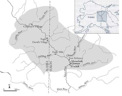
Source: H. Dobrowolsky,
Hammerstones: A History of the Tr’ondëk Hwëch’in (Tr’ondëk Hwëch’in,
2003). Map after C. Osgood with revisions by T. J. Hammer and Patricia
Halladay.
Chief Isaac's Mining
Claims
Between 1904 and 1919 Chief Isaac staked four placer mines. He may have
filed these claims to protect his cabin and subsistence sites. These
claims were located on Moosehide Creek near Moosehide Village, on Cary
Creek (just below the mouth of the Fortymile River), on the South Fork
of the Sixtymile, and on Pine Creek which flows into the Sixtymile.
|
Claim No.
|
Description
|
Date
Recorded
|
|
40491
|
No. 15
below Discovery on Cary Creek.
|
26 Sep
1904
|
|
26443
|
Creek
claim No. 27 above Discovery, on South Fork Sixty Mile River.
|
23 Dec
1911
|
|
27190
|
Creek
Claim No. 16 below Discovery on Pine Creek.
|
01 Feb
1912
|
|
32354
|
Creek
Claim No. 15 above Discovery Moosehide Creek.
|
06 Oct
1919
|
Click here for a copy of the original claim registrations.
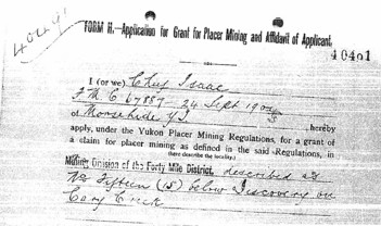
|
The Han People Today
"We are people of the river: we cannot fade away.
The Yukon is our lifeline for subsistence and survival."
Source: William Silas, The Northland News, April 1988
|
|